3,364-acre Skillet Fire reaches 82% containment
UPDATE: August 23 at 10:44 a.m.

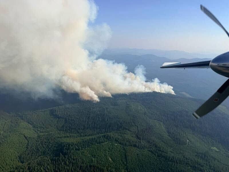
Skillet fire July 31 @ 11:28 am.
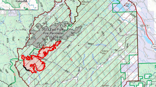
UPDATE: August 23 at 10:44 a.m.
The Skillet Fire is burning 3,375 acres west of Olney and remains 82% contained, according to an update from the Flathead National Forest.
The forest service said due to increased lightning and weather activity on Saturday night, fire crews had to pull back to safe locations and respond to other nearby fire starts. Mop-up will continue today along the Skillet Fire perimeter.
UPDATE: August 18 at 10:16 a.m.
The 3,364-acre Skillet Fire burning west of Olney is now 82% contained, according to an update from the Flathead National Forest.
Tuesday is the last day that Great Basin Complex Incident Management Team 7 will be in charge of the fire.
"This evening at 7:00pm the local Type 3 Incident Management Team will assume command of the fire," the forest service said. "The local team will continue implementing the full suppression strategy and prioritizing public and firefighter safety. During Team 7’s time on the fire strong work was accomplished by firefighters on the ground and in the air to achieve 82% containment. Despite the severity of fires across the nation and the limited availability of resources, fire managers were provided with the crews, equipment and supplies needed to protect homes, critical infrastructure and timber values."
Firefighters are expected to continue mop-up efforts for the next several days.
UPDATE: August 17 at 8:33 a.m.
Flathead National Forest said work on the Skillet Fire continued as warning levels and forest closures stayed in place.
In a Facebook post, the forest said crews moved supplies on the fire’s southwest side and used aircraft less.
Firefighters widened mop-up work beyond containment lines. On the north side, crews used drones to check for hot spots because dead trees made ground work too dangerous.
Crews also kept putting out heat in Alder Creek with hose lines.
The Facebook post said a transition began on Monday, August 17, 2026, between Great Basin Team 7 and the local Type 3 team to keep operations moving smoothly.
Officials said fire behavior was expected to stay limited, though warmer temperatures heading into Friday could bring a small increase in activity. Smoke may still be visible for weeks from fuels burning inside containment lines.
Evacuation orders for Good Creek, Alder Creek and Greg Creek were lifted and reduced to a warning on August 7, 2026, at 1:00 p.m. Closure orders for the Flathead and Kootenai national forests remained in effect.
A security checkpoint remained in place, and only residents and property owners were allowed into the closed area.
UPDATE: August 15 at 6:00 p.m.
The Skillet Fire burned acreage at 3,400 remains steady. Containment reached 55%.
UPDATE: August 13 at 6:44 a.m.
The Skillet Fire grew sightly to 3,383 acres with 39% containment when lightning and thunderstorms forced firefighters away from the fire line on Wednesday, Great Basin Incident Management Team 7 said. Despite this, incident command said containment is growing and crews are generally making progress.
"Weather permitting, heavy equipment work will continue today to provide ground crews access," incident command said.
Showers and thunderstorms may continue through the afternoon, but incident command said that the high temperatures being in the 60s with near 60% relative humidity will moderate fire behavior.
UPDATE: August 12 at 7:27 a.m.
The Skillet Fire is burning 3,375 acres around 15 miles west of Olney, and is now 32% contained, according to the Great Basin Incident Management Team 7. Incident command said containment efforts are "progressing steadily across all portions of the fire."
Incident command also said potential incoming rainfall may minimize fire spread.
"The weather will not put the fire out but will go a long way in helping these efforts," Great Basin Incident Management Team 7 said.
UPDATE: August 10 at 7:38 a.m.
The Skillet Fire is burning around the same acreage of 3,299 with containment expanded to 29%, according to an update from the Great Basin Incident Management Team 7 and the Flathead National Forest.
"Crews are working aggressively but safely to protect lives, homes, communities, and natural resources on the east and southeast to bolster effectiveness," the incident management team said. "Firefighters are making progress in the difficult terrain as they work down toward Alder Creek from the Martin Creek Road."
Relative humidity is set to increase this week, but wind gusts of 16-18 miles per hour will also be expected, which may increase fire activity.
Closures are still in place for the Kootenai and Flathead National Forests. Learn more on the Flathead County website.
UPDATE: August 9 at 10:06 a.m.
The Skillet Fire burning 3,298 acres is 11% contained, according to an update from the Flathead National Forest.
"Resources across the fire remain focused on improving, constructing, and using natural features to enhance the fireline," the forest service said. "Every effort is being made to use pre-existing roads as a containment line when feasible. Fire Managers will continue to focus effort on the southeast side of the fire to ensure we are protecting local homes and infrastructure."
For further information on closures in the Flathead and Kootenai National Forests, visit the Flathead County website.
UPDATE: August 8, 2026 11:17 a.m.
The Skillet Fire grew to 3,227 acres and is 8% contained, according to a Saturday update from fire officials.
The fire, which was caused by lightning around 15 miles west of Oiney, has 569 personnel working to contain it.
Fire officials said cloud cover over the weekend could play a role in fire activity, with more leading to decreased behavior and less leading to increased behavior.
UPDATE: August 7, 2026 at 8:38 a.m.
People who live in the Good Creek and Alder Creek area can head home at 1:00 p.m. on August 7, 2026, after evacuation rules were eased.
According to Flathead OES, the earlier evacuation order for that area was reduced to an evacuation warning. A checkpoint was expected to stay in place, with access limited to residents and property owners.
Forest closures were unchanged for everyone else. Roads, trailheads, trails, day-use areas and campgrounds in the Flathead and Kootenai national forests remained closed during work tied to the Skillet Fire.
Officials told returning residents to stay on their own property and avoid closed Forest Service land and other restricted areas. They also warned people to watch for firefighting crews, heavy equipment and emergency vehicles on local roads.
Drivers were asked to slow down, use caution and expect delays. Officials also said people should follow signs, barricades and directions from law enforcement and fire crews.
UPDATE: August 6, 2026 at 7:58 a.m.
The Skillet Fire near Olney had grown to 2,870 acres by Thursday, August 6, 2026, and an evacuation order remained in place for the Good Creek/Alder Creek area.
According to a fire update, the lightning-caused fire started July 29, 2026, about 15 miles west of Olney in the Tally Ranger District. The update listed the fire at 3% containment with 489 personnel assigned.
Crews continued building fire line on both sides of the fire after mop-up and burnout work near the heel. Aircraft also supported firefighters with retardant and water drops.
Officials warned warmer, drier weather and stronger winds could increase fire activity, especially on south-facing slopes. Moderate to heavy smoke was also expected to continue affecting nearby communities.
The Flathead County Sheriff kept the evacuation order in place for the Good Creek/Alder Creek area. The Flathead and Kootenai national forests also kept an area closure and a temporary flight restriction in place for safety.
UPDATE: August 5, 2026 at 8:06 a.m.
The Skillet fire reached 2,700 acres and was still at 0% containment as of Wednesday, August 5, 2026.
In a Facebook update, Flathead National Forest said an evacuation order remained in place for the Good Creek and Alder Creek area. Officials also kept area closures and a temporary flight restriction in place for public safety and to protect firefighting operations.
Crews on the ground and in the air were working to check the fire as hotter, drier and windier weather moved in. Smoke was also expected to keep affecting nearby communities.
UPDATE: August 4, 2026 at 6:35 a.m.
The size of the Skillet Fire did not change overnight due to a lack of infrared mapping, according to Great Basin Incident Management Team 7. It remained at 2,494 acres with zero containment.
"Today, crews will continue to construct line along roads from their anchor point on the western edge of the fire. Firefighters are placing hose lays to establish a water supply along the fire's perimeter. This system supports suppression efforts by providing firefighters with quick access to water for extinguishing hotspots and strengthening containment lines."
To sign up for evacuation and emergency alerts, visit the Flathead County Sheriff's Office website.
UPDATE: August 3, 2026 at 9:20 a.m.
The Skillet Fire has grown to more than 2,494 acres in size and remains 0% contained, according to an update from the Flathead National Forest.
244 personnel are assigned to the fire, the U.S. Forest Service said.
"Heavy equipment, including dozers and feller-bunchers, are clearing out roads to provide safe access into the fire area and construct containment lines," the U.S. Forest Service said. "Crews are establishing an anchor point on the west side of the fire and constructing dozer line from the west side of the fire down to Robertson Creek."
UPDATE: August 1, 2026 at 5:45 p.m.
The Skillet Fire burned over 1,300 acres in the Flathead National Forest. Evacuations were issued for the Good Creek and Alder Creek areas.
UPDATE: July 31, 2026 at 11:27 a.m.
Flathead National Forest reported the Skillet Fire had grown to 945 acres and Flathead County issued evacuation warnings for Good Creek Road, Old Good Creek Road, Gregg Creek Road and Alder Creek Road.
Officials said the warning meant a hazard could threaten those areas and people should be ready to leave if conditions got worse or an evacuation order was issued.
The Forest Service reported the cause was still unknown. It said the fire burned through heavy timber and moved west from Flathead National Forest across Martin Divide into Kootenai National Forest.
Firefighters were focusing on the south and southeast sides of the fire. Officials warned a Fire Weather Watch was in place for Saturday with strong winds and shifting wind directions expected as a cold front moved across ridges.
Flathead and Kootenai national forests also issued an area closure for public and firefighter safety. The closure covered Good Creek Road, Alder Creek Road, Martin Creek Road, Plume Creek Road and Martin Divide Road, along with all roads and trails reached from those routes.
UPDATE: July 31 at 8:22 a.m.
Evacuation warnings were issued July 30, 2026, for part of the Olney area because of the Skillet Creek Fire.
A Facebook post from the Flathead County Office of Emergency Services said the warning applied to Good Creek Road, Old Good Creek Road, Gregg Creek Road and Alder Creek Road.
Officials said an evacuation warning means conditions could become dangerous and residents should be ready to leave if the fire gets worse or if an evacuation order is issued.
KALISPELL, Mont. — Flathead National Forest says the Skillet Fire is burning on the Tally Lake Ranger District about three miles northwest of the Good Creek Community.
According to a Facebook post from Flathead National Forest, the fire started July 29, 2026 and was estimated at 150 acres. The cause had not been determined.
The post said crews got the report at 4:30 p.m. and the fire spread fast in hot, dry and windy conditions.
Officials said the fire was moving through thick timber with dead trees and downed wood. Smoke was visible through the late afternoon and into the evening.
The forest also said a Type 3 incident management team had been ordered along with a heavy equipment task force.
Portions of National Forest Roads 60, 60C and 2881 were closed, according to the post.